Home
Starter Site State
  • Contact Us

503-657-0331

  • Community

    Column 1

    • About West Linn
    • Residents Overview
    • Demographics
    • History
    • Mayor & City Council
    • Community Advisory Groups
    • City Meetings

    Column 2

    • Community
    • Maps
    • Videos
    • Elections
    • Emergency Preparedness
    • City Meetings
    • Social Media
    • Social Services
    • Public Access TV

    Column 3

    • Schools
    • Fire Department
    • Garbage & Recycling
    • Volunteer Opportunities
    • Neighborhoods
    • Contact the City
  • Business

    Column 1

    • Doing Business in West Linn
    • Business Resource Guide
    • Business Licensing
    • Community Partners
    • Business Grants
    • FAQs
    • Bids & RFPs

    Column 2

    • Economic Development
    • Doing Business in West Linn
    • Economic Dev. Committee
    • Tax Increment Financing (TIF)
    • Long Range Planning Projects
    • Why West Linn
    • Community Facts

    Column 3

    • Permits & Licenses
    • Business Licensing
    • Sign Permit
    • Home Occupation Permit
    • Food Trucks
    • Special Event Permit
  • Departments

    Column 1

    • City Administration
    • Communications
    • Public Records
    • Community Development
    • Building
    • Economic Development
    • Planning
    • Human Resources
    • Information Technology

    Column 2

    • Finance
    • Municipal Court
    • Utility Billing
    • Library
    • Parks & Recreation
    • Police

    Column 3

    • Public Works
    • Engineering
    • Maps/GIS
    • Water
    • Sewer
    • Stormwater
    • Streets
    • Contact the City
    • Hours of Operation
    • Report a Concern
    • Staff Directory
  • How Do I...

    Column 1

    • Apply For
    • Advisory Committee
    • Building Permit
    • Business License
    • Council or Mayor Position
    • Job
    • Library Card
    • Planning Permit
    • Recreation Classes
    • Tree Permit
    • Volunteer
    • Request
    • Building Inspection
    • City Services
    • Police Public Record
    • Public Record
    • Public Works Inspection
    • Traffic Safety Improvement

    Column 2

    • Pay Online
    • Business License
    • Court / Traffic Fee
    • Recreation Classes
    • Utility Bill
    • Find
    • Bids & RFPs
    • City Codes
    • City Events
    • City Meetings
    • Emergency Information
    • Event Space
    • Forms
    • Garbage and Recycling
    • Hours of Operation
    • Library Catalog
    • Maps
    • Neighborhood Association
    • Press Releases

    Column 3

    • Connect
    • City Council
    • City Meetings
    • City News
    • E-mail Subscriptions
    • Financial Dashboard
    • Social Media
    • Staff Directory
    • Report
    • Animal Complaint
    • Code Enforcement Request
    • Misconduct, ethics, or fraud
    • Hazard or City Issue
    • Police Tip
    • Streetlight Problem
    • Traffic Concern
    • Tree / Vegetation Complaint
    • Water / Sewer / Street Issue

Search the Website

Maps / GIS

Historic West Linn Plat Maps

Map Preview

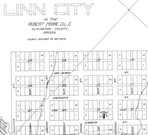
View, Download, and Print Historic Subdivision Plat Maps in West Linn

Supporting Documents

PDF icon Linn City, 1844 Survey 001 (4 MB)
PDF icon Plat 36, West Side Addition, 1889 (124 KB)
PDF icon Plat 41, Windsor, 1889 (281 KB)
PDF icon Plat 43, Weslynn, 1889 (119 KB)
PDF icon Plat 99, Sunset City, 1892 (752 KB)
PDF icon Plat 121, Willamette Falls, 1893 (1 MB)
PDF icon Plat 133, Bolton, 1901 (168 KB)
PDF icon Plat 138, Willamette Falls Acreage Tracts, 1901 (239 KB)
PDF icon Plat 138, Willamette Falls Acreage Tracts, 1901 (267 KB)
PDF icon Plat 147, Willamette Tracts, 1903 (337 KB)
PDF icon Plat 198, Willamette and Tualatin Tracts, 1908 (446 KB)
PDF icon Plat 206, Shannon Acres Tracts, 1909 (191 KB)
PDF icon Plat 304, Bland Acres, 1911 (196 KB)
PDF icon Plat 363, Willamette Heights, 1913 (206 KB)
PDF icon Plat 366, Moody's Subdivision of Unit C West Oregon City, 1913 (143 KB)
PDF icon Plat 368, West Oregon City, 1913 (188 KB)
PDF icon Plat 372, Brittons Subdivision of Part Of Tract O&N of Will.Falls Acreage Tracts, 1910 (115 KB)
PDF icon Plat 412, West Linn Heights, 1916 (195 KB)
PDF icon Plat 443, Moody Investment Co. Plats of Holly Gardens, 1923 (2 MB)
PDF icon Plat 451, Robinwood, 1930 (1 MB)

Related Links

View other Historic West Linn Maps
  • Printer-friendly version
  • About GIS
    • About West Linn's GIS
    • GIS Map Fees and Pricing
    • GIS Data Portal, GIS Datasets
    • GIS Map Disclaimer
    • Quick Facts about West Linn
  • Mapping Tools
    • West Linn Maps
    • Clackamas County GIS CMap
    • Land Survey Information System (CCSIS)
    • Oregon Department of Transportation (ODOT) TransGIS
    • ORMAP Assessor Tax Maps
    • HazVu Geohazards Viewer
    • Tri-Met Bus Routes Trip Planner
    • Water Rights Mapping Tool
    • Metro Maps
    • Geology and Geologic Hazards
    • Oregon Department of Transportation (ODOT) TransGIS
  • Popular Maps
    • Atlas of West Linn Oregon
    • West Linn Road Map and other Base Maps
    • City Map
    • Bike Map
    • Neighborhood Associations Maps
    • School District Maps and Bus Routes
  • Other Maps
    • Backyard Burning Boundary Map, TVF&R
    • City Owned Property Map
    • Earthquake Maps
    • Flood Insurance Maps
    • Goal 5 Inventory Maps
      • Goal 5, Local Wetland Inventory
      • Goal 5, Open Space Inventory
      • Goal 5, Significant Riparian Corridors
      • Goal 5, Wildlife Habitat Inventory
    • Historic Maps
      • Historic Resource Map
      • Historic Survey Maps
      • Historic Sanborn Maps
      • Historic West Linn Plat Maps
      • West Linn City Hall 1936 Construction Drawings
      • West Linn Railway Map
      • Willamette Historic District Inventory Maps
    • Landslide Maps
    • LiDAR Surface Model and Contours/Topo
    • Natural Hazards Mitigation Maps
    • Parade Route
    • Sandbag Locations Map
    • Stafford Basin Maps
    • Street Pavement Condition Rating Map
    • Street Sweeping
    • Street Tree Inventory Map
    • Water Main Breaks in West Linn
    • Water Resource Area (WRA) Map
    • Water System Map Pipe Age
    • Winter Weather Routes
    • Map Making Kit
    • Coloring Map
    • Zoning Map
  • Park Maps
    • Trail Maps
    • City Facilities and Parks, How to get there and Site Maps
    • Printable Map of City Parks
    • Mary S Young Park
    • Willamette River Guide
    • Palomino Loop Trail Map
    • McLean House Vicinity Map

Contact Information

Maps/GIS

  • Email:  gis@westlinnoregon.gov
  • Main Phone (Engineering):   
    503-722-5500
View Full Contact Details

Upcoming Events

  • Memorial Day - City Offices Closed
    05/26/2025 (All day)
  • Juneteenth - City Offices Closed
    06/19/2025 (All day)
  • Independence Day - City Offices Closed
    07/04/2025 (All day)
  • Labor Day - City Offices Closed
    09/01/2025 (All day)
  • Veteran's Day - City Offices Closed
    11/11/2025 (All day)
  • Thanksgiving Day - City Offices Closed
    11/26/2025 (All day)

View the Monthly Calendar

  • Home
  • Contact Us
  • Sitemap
  • Staff Login

22500 Salamo Rd. | West Linn, OR 97068

Terms & Conditions        a municode design