Land Survey Information
Look up land surveys on-line: Clackamas County Survey Information System (CCSIS)
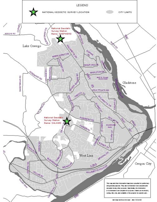
Geodetic Survey Stations in West Linn: there are two NGS survey stations available in West Linn: SALAMO and SHEPHERD. Also contact Clackamas County Surveyor for more information on surveys in West Linn.
Lookup National Geodetic Survey Control Points on-line: NOAA National Geodetic Survey Interactive Map
Search National Geodetic Survey Station Datasheets
Map of Geodetic Survey Stations in
West Linn, jpg
Map of Donation Land Claims in
West Linn, pdf
Helpful websites:
The Oregon Real-Time GNSS Network - ORGN is Fully Functional - Global Navigation Satellite System
Oregon GNSS Users Group
National Geodetic Survey, NOAA
Professional Land Surveyors of Oregon
Oregon Association of County Engineers and Surveyors
About Cadastral Surveys
GLO Records
BLM Land Status & Cadastral Records Viewer
Clackamas County Surveyor's Office
Phone: (503) 742-4475
150 Beavercreek Road, #319
Oregon City, OR 97045
Web Site: http://www.clackamas.us/surveyor
There is one NGS Survey Station in West Linn
Name: SALAMO
Location: THE STATION IS LOCATED ABOUT 16.7 KM (10.4 MI) SOUTH OF PORTLAND, 2.7 KM (1.7 MI) WEST OF WEST LINN, 0.3 KM (0.2 MI) NORTHERLY OF PARKER ROAD, ON TOP OF A HILL, AT THE SOUTHEAST CORNER OF THE ROSEMONT RIDGE MIDDLE SCHOOL GROUNDS, IN T.2 S., R. 1 E., W.M.
USGS Quad: CANBY (1985)
PID: AJ8196
State/County: OR/CLACKAMAS
NGS Survey Station north of West Linn
Name: SHEPHERD
Location: THE STATION IS LOCATED ABOUT 13.4 KM (8.3 MI) SOUTH OF PORTLAND, 2.7 KM (1.7 MI) SOUTH OF LAKE OSWEGO, ON STATE HIGHWAY 43, AT THE ENTRANCE OF MARYLHURST UNIVERSITY, IN T. 2 S., R. 1 E., W.M.
USGS Quad: LAKE OSWEGO (1984)
PID: AJ8198
State/County: OR/CLACKAMAS