HazVu Geohazards Viewer
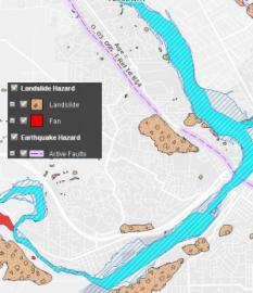
Oregon HazVu: Statewide Geohazards Viewer provides a way to view many different geohazards in the state of Oregon.
You can enter the address for your home, school, business, or public buildings in your area to see what hazards might affect you. You can print the map you create.
Geohazards include 100-year flooding, Cascadia Subduction Zone earthquake shaking and tsunami, coastal erosion, volcano, landslide, active faults, earthquake soft soil, and more. Assets include state-owned/leased facilities and public buildings such as schools, police and fire stations, and hospitals, as well as links to seismic assessment reports for these public buildings.
Please be aware that not all geohazards have been completely mapped, but this viewer shows the best available data from DOGAMI. Use the Web link below to enter the HazVu website.