Water Resource Area (WRA) Map
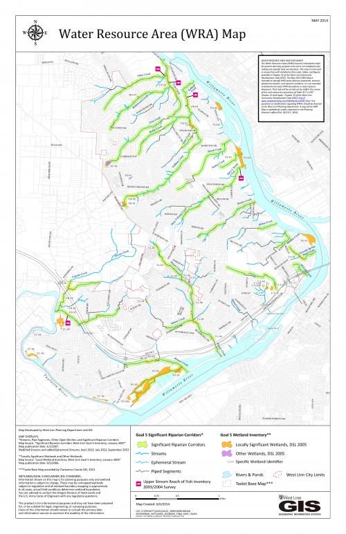
The Water Resource Area (WRA) Map shows approximate locations of streams within West Linn's city limits. Also included is the 2005 Wetland Inventory and 2007 Significant Riparian Corridors, both developed for the Goal 5 Inventory by the West Linn Planning Department.
Please be aware of the following limitations regarding this map. Use the link below to view Chapter 32 of the West Linn Community Development Code for more information on WRA's.
WATER RESOURCE AREA MAP DISCLAIMER / LIMITATION REGARDING THIS MAP: The Water Resource Areas (WRA) map has interpretive value for general planning purposes only and is not satisfactory for making site-specific land use decisions. This map is to be used in conjunction with detailed written code, tables, and figures provided in Chapter 32 of the West Linn Community Development Code (CDC). The May 2014 WRA Map is intended to identify WRA water features (wetlands, streams, ephemeral streams, and riparian corridors). It is not intended to delineate the exact WRA boundaries or water feature alignment. That task will be carried out by staff in the course of site visits where the provisions of Table 32-2 in CDC Chapter 32 shall apply. Chapter 32 of the West Linn Community Development Code (CDC): http://www.codepublishing.com/OR/WestLinn/CDC.html. Any questions or clarifications regarding WRA’s should be directed to the West Linn Planning Department. A copy of the WRA Map is available for public inspection in the Planning Director’s office (Ord. 1623 § 1, 2014)